

Speedmap Included in PSGA
05/10/2025News:
First Great Britain 20mph Speed Limit Map Launched
Unique analysis of speed limits in Great Britain launched together with regional and local area data

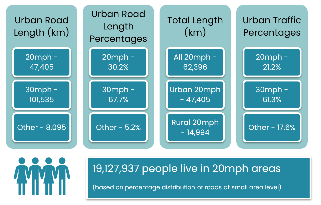
In our towns and cities in Great Britain, over 30% of roads are now subject to a 20mph speed limit*, rather than the traditional 30mph one.
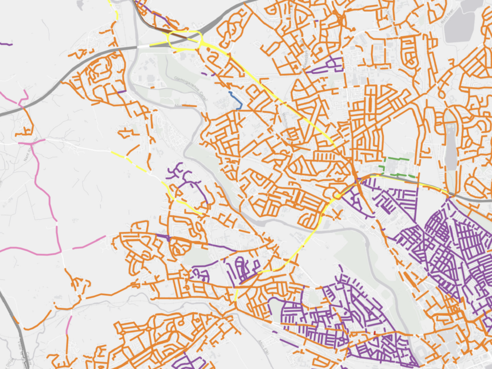
This new research shows for the first time the extent to which road authorities have adopted lower speed limits, providing results at country, regional and local level. This analysis is backed by an online map which is free to access and allows anyone to see how speed limits vary in their area compared to others.
*Data analysed as at January 2025
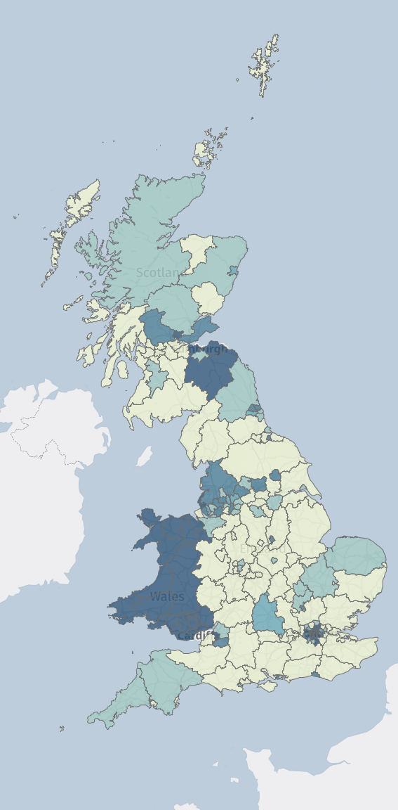
Wales has led the way in terms of adopting lower speed limits following the widespread, but not blanket change in urban speed limits. This analysis shows that just over 90% of urban roads in Wales are now set at 20mph, a complete contrast to the West Midlands where just less than 10% of urban roads are at that lower limit.
Progress has been made in London with more than half of all urban roads subject to lower limits, and the North-West of England is following closely with over 45% of roads at 20mph.
There are some regions where, like the West Midlands, there has been lower rates of adoption of 20mph. The East, East Midlands and South East of England all have adoption rates that are less than half the GB average.
Across the roads analysed, 30.2% were set to 20mph, with 30mph roads making up 67.7% of urban road speed limits.
In terms of traffic miles driven the figures are much lower with only around 21.2% of urban journeys taking place on roads with the lower speed limit. This shows that implementation of lower speed limits has historically been on low-flow, residential roads rather than busy connector roads where a higher speed limit might be more appropriate if there are safety measures to protect vulnerable road users.
In terms of the population, we have estimated that around 19.1m people now live in neighbourhoods with a 20mph limit.
We have worked on this national map of speed limits for over a decade; improving the data coverage, quality, and timeliness to achieve this highly-detailed map. This is the first time a full nationwide analysis of speed limits has been undertaken by anyone.
This data is already used by car manufacturers, technology companies, and the insurance sector to improve safety and lower premiums - now the results make the public aware of how their roads compare to others elsewhere in Great Britain.
England (excl London)
Bristol and Sefton lead the way with over 80% of roads in urban areas being 20mph. In contrast, Dudley, Buckinghamshire, Worcestershire,
Lincolnshire, Hertfordshire, and North Lincolnshire all have less than 2% of urban roads subject to the lower limit.
London
The City of London is the only area in Great Britain with 100% of roads at 20mph. Westminster, Hackney, Camden, and Islington are all above 95%. Meanwhile Bexley, Hillingdon, Bromley and Barnet all show less than 10% of roads at 20mph.
Scotland
East Lothian, Scottish Borders, Clackmannanshire, and City of Edinburgh all have over 80% of urban roads at 20mph. There are ten authorities that have virtually no 20mph limits (see report for full details).
Wales
With a default national limit of 20mph it is unsurprising so see that all authorities have very large percentages of road that are subject to the lower limit. There are however some significant differences with Blaenau Gwent showing 84% compared to Denbighshire with nearly 99% or urban roads at 20mph.
The data shows a clear difference in the implementation of 20mph speed limits around Great Britain with the lower urban speed limit becoming the default across many urban areas. Even within the same city region or wider areas there are stark differences in approach. The impending review and changes in Scotland will be fascinating to observe to see whether there is the same level of relative uniformity seen in Wales.
Although some data has been provided on 20mph limits in rural areas this has not been analysed in detail, partly due to some complications in the potential methodology.
Defining what a settlement looks like in rural areas is difficult with no national classification system in place. Many residential properties in the countryside don’t have restricted roads nearby (those subject to the national 30mph limit) which would make analysis complicated.
We are certain however that rural communities do not have the same lower speed limits nearby as those in built-up areas.
Away from the matter of speed limits, we have not measured traffic speeds. A 30mph limit does not equal traffic travelling at 30mph with time spent waiting at junctions, or queueing in traffic having a significant impact on journey time. We have similarly not reviewed the impact of changing speed limits on road casualties. This type of study requires in-depth analysis and is typically carried out by Highway Authorities themselves.
There is a lot more we can do with the data and we look forward to exploring the potential for further research next year.
Frequently Asked Questions
Data Sources
- Insight Warehouse “SpeedMap GB” database of speed limits for individual roads, matched to Ordnance Survey road network. Ordnance Survey data can be accessed by PSGA members free of charge (https://www.ordnancesurvey.co.uk/customers/public-sector/public-sector-geospatial-agreement) commercial supply is available via https://osdatahub.os.uk/. Insight Warehouse also supply access to their database directly for commercial clients through an API and file download.
- LSOA boundaries for England and Wales and Regional Boundaries for England including rural/urban classification (https://geoportal.statistics.gov.uk/)
- LSOA populations for England and Wales (https://www.ons.gov.uk/peoplepopulationandcommunity/populationandmigration/populationestimates/datasets/lowersuperoutputareamidyearpopulationestimates)
- Scotland small area statistics (data zones) including boundaries and populations and rural/urban classification (https://www.gov.scot/collections/small-area-statistics/)
- Small Area traffic data supplied by Agilysis Ltd (https://agilysis.co.uk/) derived from multiple GPS and ground-truth data sources. Contact info@agilysis.co.uk for further information.
Insight Warehouse have made the datafile that supports the analysis publicly available for download, please visit 20mph.speedmap.co.uk for details